

Wadaslintang Reservoir
Wadaslintang reservoir is located in the District of Purworejo Central Java Province Indonesia with cathment area is 192.58 km2. Its was built in 1989 with a capacity of 443 million m3 and provide waters for various needs such as irrigation, fishery, electric power, industry, household consumption and others. The current condition at the upstream area of the reservoir indicate a change in water availability.
Water availability is amount of rainfall that arrested in a watershed and transformed became runoff for a period. In water resources management, Its very important to know the water availability as a base to arrange the regulation related to water use for various needs. Study on monitoring and evaluation of watershed condition in 2010 by Serayu Opak Office, Ministry of Public Works shows the upstream watershed of the reservoir is in good condition, but the ratio of annual water yield and the reservoir capacity is 0.4, Its mean that there is a discrepancy between plan and actual water yield.
At the same year in 2010, also implemented the research on Quantitative Evaluation Model of Irrigation Performance at Wadaslintang Irrigation System downstream of Wadaslintang Reservoir by Serayu Opak Office and the result show that the irrigation performance is not good in water service, especially in dry season. To solve this problem, need to arrange a good water resources management by considering the water availability.
Map of Wadaslintang Reservoir Cathment Area
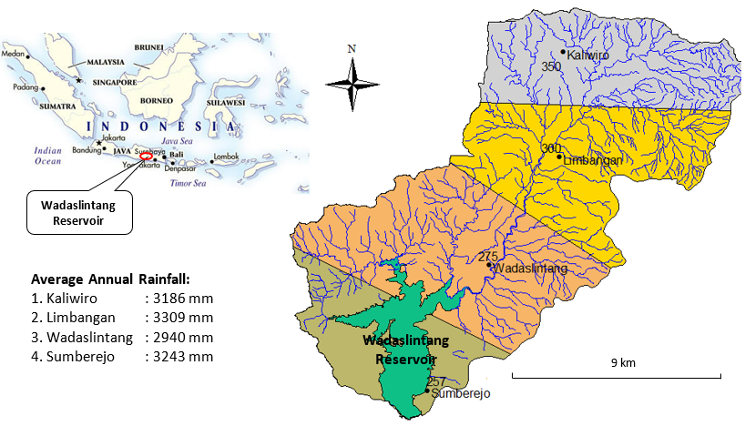
Rainfall data was used as input to measure water availability. The data collected from four rain gauges in Kaliwiro (in altitude 350 m msl), Limbangan (in altitude 350 m ms), Wadaslintang (in altitude 275 m msl) and Sumberejo (in altitude 257 m msl). Rainfall zonation divide upstream area of the reservoir became four part based on number and position of the rain gauges (see figure below). Each part of has the meaning that the value of rainfall in that area is same and water availability will be analized in each area using hydrologic analysis. The largest area of rainfall zone is Wadaslintang with area 63.44 km2, Limbangan with area 51.14 km2, Kaliwiro with area 43.73 km2 and Sumberejo with area 34.21 km2. Number of the rain gauges in this area is in good category. WMO recommend one raingauge for every area 600-900 km2 in tropical region.
The annual rainfall in the upstream of Wadaslintang Reservoir is high enough and includes category of tropical regions where rainfall reaches 3000 mm/year (> 700 mm/year). Temperature is between 220C-26.30C and land slope dominated by area between 0-15% with the highest slope area located in east side. Type soil in the watershed dominated by latosol and podzolic soils. Soil type are very conducive to agricultural activities, so that in the upstream of the reservoir is growing number of agricultural areas conducted by the local community.
The total annual water discharge of Wasalintang reservoir is 353.31 million m3, where the highest water discharge was from Limbangan around of 103.39 million m3, and then Wadaslintang was 102.69 million m3, Kaliwiro was 81.32 million m3 and Sumberejo was 65.91 million m3. Figure below shows water availability at Wadaslintang Reservoir.

Water Availability of Wadaslintang Reservoir
There are two monsoon in Indonesia, dry season (from April to September) and wet season (October to March). Water availability patterns following the monsoon where the waters is available in huge number at wet season and decrease at dry season.
ACKNOWLEDGEMENT
This article is part of research in the year of 2009 under guidance of Prof. Sahid Susanto, Faculty of Agricultural Technology UGM and funding by Main Office of Serayu-Opak River Basin Development (BBWS.SO), Yogyakarta. For that reason, our thank is addressed.