

Map of Upstream of Serayu Watershed
The upstream area of the Serayu watershed situated around the Dieng Plateau was in danger of degradation due to the land over-exploitation for agriculture. The uneven land topography with steep slopes increased the potential damage of the watershed. In addition, the watershed sedimentation level was also high due to the erosion and landslide along the river line. Dealing with this situation, the Directory of Water Resources of the Minsitry of Public Works via the Office of Serayu-Opak River Basin Development (BBWS.SO) in collaboration with the Department of Agricultural Engineering, the Faculty of Agricultural Engineering Technology UGM, designed an integrated conservation program. The program was conducted by constructing buildings to control the sediment, gully plug; planting conservation plants and strengthening of river channel; and repairing the water facilities and infrastructure. The program used demonstration plots by involving the local community. The program took place in Patak Banteng Village, Kejajar District, Wonosobo Regency, which was geographically included in the upstream area of Serayu watershed.

Socialization of the Program
The establishment of the demonstration plots involved the local community through the local government and local groups. The community played the role as the executor, maintainer, and beneficiary of the plots, whether direct or indirect, while the government through the Office of Serayu-Opak River Basin Development (BBWS-SO) acted as the provider of the facilities and materials. Meanwhile, the academic institution (UGM) played the role in giving guidance, supervision, and assistance to the program, as well as conducting dissemination, socio-economic survey, improvement of awareness and the community’s role in the conservation program, design production, and evaluation.
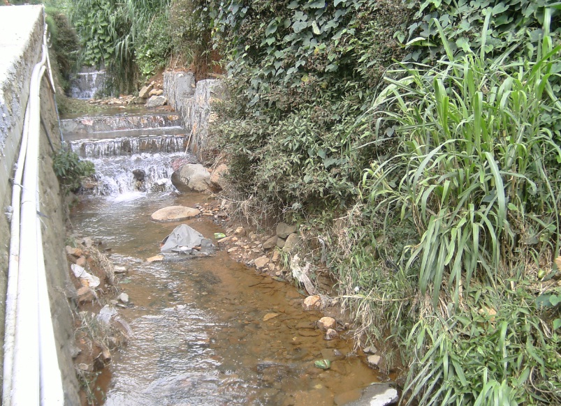
Gully Plug
The gully plug design of stone-pair used the shape of dam consisting of mica floors, crest weir, stilling basin, and wings. The front floor of the dam functioned as protection for the building from the piping effect which might erode the building base. The crest weir was in the shape of ogee equipped with streamline effect which allows water to move following the shape of the crest weir; thus, it would not damage the building as it was elevated in accordance with the desired depth of the tunnel. Meanwhile, the stilling basin was built a bit deeper and functioned as the building foundation. The upstream part was elevated to be equal with the tunnel base to avoid erosion caused by the water. The wing parts were built to direct the water and prevent it from flowing to the sides of the building.

Sediment Control Building in Shape of Gabions Construction
The Sediment Control Building (BPS) was in the shape of gabions construction, equipped with fibers of palm tree in the front part of the crest weir. The building was designed in such a way that it looked like a dam consisting of crest weir, stilling basin, and gabion construction wings. The crest weir part was equipped with fibers of palm tree to elevate the water surface to be as high as the crest weir, so the farmers could easily access the water. For the sake of security, the upstream part was given a pile of gabions to avoid erosion caused by the water. The gabions construction wings in the upstream and downstream parts were made to be leaning horizontally to direct the water not to flow through the sides of the The gabions construction as it might endanger the building stability. The pile of the The gabions construction was built alternately to create strong bound.

Planting of Conservation Plant
The conservation plant, pines—as chosen by the community, were placed along the watershed in the BPS location, Gully Plug, and the springs.
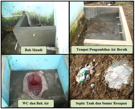
Improvement of Sanitation Facilities
The improvement of sanitation facilities included the building of clean water resources, bath container, squat closet, clean and dirty water pipes, septic tank, and absorption well. The establishment of demonstration plot for water resources conservation in general received positive responses from the community. For example, the water in the gully plug was used by the community to irrigate the potato farms. In addition, the sanitation facilities and access to clean water were also directly used by the community.
ACKNOWLEDGEMENT
This program could not be realized without financial support from Main Office of Serayu-Opak River Basin Development (BBWS.SO), Yogyakarta. For that reason, our thank is addressed. Our thank is also addressed to our team: Prof. Sahid Susanto (team leader), Ir. Sukirno MS., Prof. Sigit Supadmo Arief, Prof. Moch. Maksum from Faculty of Agricultural Technology UGM and Ir. Sigid Santoso MM., from BBWS.SO, Yogyakarta for their contribution in the program.