
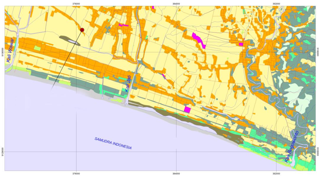
Map of Jati River
The Serayu-Opak watershed consists of several rivers heading to the Hindia Ocean, namely Jali River and Bogowonto River. In general, the rivers have several sub-rivers in both the upstream and downstream. The ones in the upstream, such as Lereng River and Jati or sand which connect Mawar River, Jali River, and Bogowonto River, are characterized by their shallow wall making them vulnerable to flood. The rivers lie along the coastal line and are situated nearby the beach with their estuaries adjacent to those of Bogowonto River and Jali River
The flow of Lereng River and Jati or Pasir River is really determined by the condition of Bogowonto River and Jali River, especially when the flood occurs or the estuaries of the two rivers are closed. Jati River and Pasir River flow throughout the coastal sand field and in the surrounding areas there are permanent and temporary water pond which have not been optimally used. The potential area covers approximately 0.5 km x 14 km or 7 km2, which is equal to 700 ha, consisting of rain farm field and inundated land. The land potential for fisheries development includes the permanent inundated land covering 0.2 km x 14 km or 2.8 km2 or 280 ha.
In the period of 2008-2009 a freshwater fisheries farming was tested in the areas of Jati River swamp located in two locations: Dudu Kulon Village and Giri Rejo Village. The program was collaboratively conducted by the Department of Agricultural Engineering UGM and the Office of Serayu-Opak River Basin Development (BBWS-SO) involving the farmer group of “Mina Raharja” in Girirejo Village and the group of brackish water fisheries farmer “Lestari” in Dudu Kulon.

Provision of Fish Seed
The demonstration plots are located in Girirejo and Dudukulon Village covering 4,500 m2 for each, cultivating karper, red nila, and gift nila with the breeding size of 5 cm-7 cm. The breeds consisted of 2,000 karpers, 4,000 red nilas, and 5,000 gift nilas. The breeds were spread on 25 July 2009 and were harvested on 1 and 5 October 2009 resulting in karper 400 kg of karper, 300 kg of red nila, and 600 kg of gift nila. The ponds in Girirejo Village used natural feed (algae, wide-leaved, freshwater shrimp, and 60 kg of pellet) which were abundant around the village. After three months, the fish were ready to harvest as the fish rapidly grew due to the abundant stock of feed.

Fish Harvesting
The followings are some of the required technological inputs:
- Build sluice gate to control the water and drainage for land based on hydrological analysis of the Bonorowo south coastal areas.
- Conducting analysis of land suitability and agricultural land grouping based on hydrological characteristics of the area and the soil type.
- Determining the non-pond planting pattern.
- Conducting coordination on inter-institutional activities among the departments in Purworejo Regency.
- Building road infrastructure facilities in the target location from the village entrance gate heading to the main location
ACKNOWLEDGEMENT
This program could not be realized without financial support from Main Office of Serayu-Opak River Basin Development (BBWS.SO), Yogyakarta. For that reason, our thank is addressed. Our thank is also addressed to our team: Prof. Sahid Susanto (team leader), Ir. Sukirno MS., Prof. Sigit Supadmo Arief, Prof. Moch. Maksum from Faculty of Agricultural Technology UGM and Ir. Sigid Santoso MM., from BBWS.SO, Yogyakarta for their contribution in the program.
Text in Indonesian